


Le Tarn naissance d' une grande riviere 352 +

claude nier
User
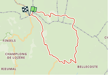

Length
18 km

Max alt
1577 m

Uphill gradient
352 m
Km-Effort
23 km

Min alt
1348 m

Downhill gradient
353 m
Boucle
Yes
Creation date :
2025-01-26 19:10:57.914
Updated on :
2025-01-26 19:12:13.286
5h09
Difficulty : Very difficult

FREE GPS app for hiking
 SityTrail
IGN / Geographical institutes
SityTrail Plus
The world is yours!
About
Trail Walking of 18 km to be discovered at Occitania, Lozère, Mont Lozère et Goulet. This trail is proposed by claude nier.
Description
depart Col de Finiels
Positioning
Country:
France
Region :
Occitania
Department/Province :
Lozère
Municipality :
Mont Lozère et Goulet
Location:
Mas-d'Orcières
Start:(Dec)
Start:(UTM)
561218 ; 4919245 (31T) N.
Comments